SPACE MART SPACE DAILY SPACE WAR TERRA DAILY MARS DAILY SPACE TRAVEL GPS DAILY ENERGY DAILY
  Space Industry and Business News  
Get Our Free Newsletters Via Email
  
Search All Our Sites at SpaceBank
Weather Underground Launches Best Weather Map Available On The Internet

Thousands of station owners already participate in the Weather Underground worldwide network, allowing the company to provide accurate and up-to-the-minute weather information.
by Staff Writers
San Francisco CA (SPX) May 06, 2008
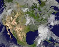
Weather Underground has announced the availability of its new interactive weather map. Sharing its namesake with the website, the WunderMap is an interactive visual display of weather information that is plotted and overlaid on a map interface.

Users can choose from a variety of weather layers, including animated radar, current conditions, severe thunderstorm and tornado warnings, live webcam images and animated infrared or visible satellite imagery showing cloud coverage.

Users will find the new feature useful in that it provides a meaningful and uniform representation of multiple types of weather data in an easy to use, interactive format.

The level of user-interactivity that can be achieved with the WunderMap makes it a powerful tool for avid meteorologists, while still maintaining a clean and intuitive design for the casual weather observer.

"We have created the most comprehensive, user-friendly interactive weather map available," said Alan Steremberg, president and co-founder of Weather Underground. "No other online weather map offers such a range of options or layers that can be overlaid or taken away as directed by the user. Someone can select to see only the radar loop or they can choose to view the temperature readings from the Personal Weather Stations in any given area."

In addition to the new WunderMap feature, Weather Underground currently offers a comprehensive suite of weather related services, including the recently announced sports weather feature, streaming weather radio, personal WebCams, Wunder Photos, and the Personal Weather Station (PWS) network, which allows users to link their home-based automated weather stations to the Weather Underground community.

Thousands of station owners already participate in the Weather Underground worldwide network, allowing the company to provide accurate and up-to-the-minute weather information.

Community
Email This Article
Comment On This Article

Related Links
Weather Underground
Earth Observation News - Suppiliers, Technology and Application


RADARSAT-2 Commissioned And Ready For Commercial Operation
Richmond, Canada (SPX) May 02, 2008
MacDonald, Dettwiler and Associates has announced that RADARSAT-2 completed its commissioning on April 25, 2008 and fully transitioned into commercial operations to deliver advanced radar images of the Earth. Launched from Baikonur Cosmodrome on December 14, 2007, RADARSAT-2 delivered its first sample high-resolution radar images on December 18, 2007.


Memory Foam Mattress Review

Newsletters :: SpaceDaily Express :: SpaceWar Express :: TerraDaily Express :: Energy Daily
XML Feeds :: Space News :: Earth News :: War News :: Solar Energy News
  • Google wins from end of Microsoft-Yahoo affair: analysts
  • Microsoft takeover deadline for Yahoo expires without comment
  • China world's largest Internet market
  • World's Fastest Satellite Internet Connection To User Terminal Via KIZUNA

  • ULA To Launch GRAIL
  • Khrunichev And ILS Announce Quality Initiative
  • Kalam Hails ISRO For Satellite Launch
  • Zenit Rocket Puts Israeli Satellite Into Orbit

  • Analysis: Can airplanes go green?
  • Belgian airline says it will cut costs, emissions by slowing down
  • Airbus, Boeing sign accord to cut air traffic impact on environment
  • Oil spike, cost of planes led to Oasis collapse: founders

  • Work Continues On New Satellite Communications Antenna System For B-2 Bomber
  • Raytheon Awarded Contract To Upgrade Satellite Communication Terminals
  • General Dynamics And Cisco Systems Advance Battlefield Networking
  • BAE To Develop Military Communications Network

  • SES ASTRA Starts New Orbital Position At 31.5 Degrees East
  • NASA Ames Partners With m2mi For Small Satellite Development
  • Loral Spins A Giant Web In Space As First ICO Bird Comes Alive
  • COM DEV Launches Advanced Space-Based AIS Validation Nanosatellite

  • NASA names science directorate deputy
  • Northrop Grumman Names Terri Zinkiewicz VP Sector Controller For Its Space Technology Sector
  • Northrop Grumman Appoints Scott Winship To VP And Program Manager - Navy Unmanned Combat Air System
  • NASA Names John Shannon New Space Shuttle Manager

  • Weather Underground Launches Best Weather Map Available On The Internet
  • RADARSAT-2 Commissioned And Ready For Commercial Operation
  • Subsystems Of Cartosat-2A, IMS-1 Functioning Satisfactorily
  • 4D Ionosphere

  • Microsoft Takes Geotagging Mainstream With New Digital Photo Products
  • Remote Management Of DGPS Broadcast Sites For Marine Navigation
  • Walk Out Working: Best Buy Pledges Immediate Access To Summer Technology
  • US Streetlight Grid Could Become Affordable Communications Back-Haul Network

  • The content herein, unless otherwise known to be public domain, are Copyright 1995-2007 - SpaceDaily.AFP and UPI Wire Stories are copyright Agence France-Presse and United Press International. ESA Portal Reports are copyright European Space Agency. All NASA sourced material is public domain. Additional copyrights may apply in whole or part to other bona fide parties. Advertising does not imply endorsement,agreement or approval of any opinions, statements or information provided by SpaceDaily on any Web page published or hosted by SpaceDaily. Privacy Statement