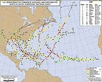
NOAA's official map of tropical cyclone tracks during the Atlantic Ocean season 2008. Credit: NOAA NHC. For a larger version of this image please go here.
NOAA's official map of tropical cyclone tracks during the Atlantic Ocean season 2008. Credit: NOAA NHC. For a larger version of this image please go here. |
There were 17 tropical cyclones in the Atlantic Hurricane Season, which includes the North Atlantic Ocean, Caribbean Sea and Gulf of Mexico. Sixteen of the storms were strong enough to be named, and only one stayed a tropical depression.
The movie displays the infrared cloud imagery from the geosynchronous weather satellites, principally NOAA's Geostationary Operational Environmental Satellite (GOES)-12.
The original cloud imagery was remapped and enhanced to display cloudtop texture. The GOES cloud images were overlaid on a true-color background map previously created from the Moderate Imaging Spectroradiometer (MODIS) instrument on NASA's Terra satellite.
The movie, which can be found on NASA's Hurricane Web page (www.nasa.gov/hurricane), or on the NASA GOES web page, is television production-quality. "These are large, high-resolution, colorful animations, made for use or editing by professional documentary producers or for anyone interested in hurricanes," said Dr. Dennis Chesters, GOES Project Scientist at the Laboratory for Atmospheres at NASA's Goddard Space Flight Center, Greenbelt, Md.
The movie depicts the entire 2008 hurricane season based on six months of GOES imagery at 30 minute intervals from May 1 to November 18, 2008. Each "frame" has a date and time stamp with the times in Universal Coordinated Time (UTC). There are 2 versions of the movie available: a 720p and 1080p HD-TV digital animation.
"Most versions are overlaid with hurricane names and storm tracks, with the tracks represented by dots whose size and color represent NOAA's hurricane Category 1 to 5 (on the Saffir-Simpson Scale)," Dr. Chesters said. "Some movies have captions summarizing each storm in a sidebar. Movies without named tracks are useful for forecasters and researchers who want to see the regional meteorology without visual distractions."
Share This Article With Planet Earth
 del.icio.us del.icio.us |
 Digg Digg |
 Reddit Reddit |
 YahooMyWeb YahooMyWeb |
 Google Google |
|
 TerraSAR-X Image Of The Month: Piton de la Fournaise
| The content herein, unless otherwise known to be public domain, are Copyright 1995-2009 - SpaceDaily. AFP and UPI Wire Stories are copyright Agence France-Presse and United Press International. ESA Portal Reports are copyright European Space Agency. All NASA sourced material is public domain. Additional copyrights may apply in whole or part to other bona fide parties. Advertising does not imply endorsement,agreement or approval of any opinions, statements or information provided by SpaceDaily on any Web page published or hosted by SpaceDaily. Privacy Statement |