The National Polar-orbiting Operational Environmental Satellite System (NPOESS) team led by Northrop Grumman kicked off the new year with the delivery of a critical sensor, the Visible Infrared Imager Radiometer Suite (VIIRS).
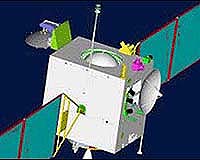
NPOESS is the nation's next-generation, low-Earth orbiting operational weather and climate monitoring system that will provide operational and long-term weather and climate data to military and civilian users around the clock for the next two decades.
As part of the NPOESS system, VIIRS will provide highly detailed color imagery of clouds, vegetation, snow cover, dust storms and other environmental phenomena.
"The delivery of VIIRS enables us to move ahead on an advanced system consisting of spacecraft, sensors, and a ground segment that is already well underway," said Dave Vandervoet, NPOESS program manager for Northrop Grumman Aerospace Systems.
"This program made terrific progress last year, and the vast majority of the development risk is behind us now. The sensor that was delivered will be integrated on to the NPOESS Preparatory Project spacecraft, which will be launched next year."
Raytheon built the instrument under contract to NPOESS prime contractor, Northrop Grumman.
A second VIIRS flight unit scheduled for deployment on the first NPOESS spacecraft, known as C1, is maturing steadily. Component production is in progress and build up of the sensor is on-going.
NPOESS represents state-of-the-art advancements in science and technology as applied to weather, climate, and related environmental information. The system captures research and development investments that have been made by military and civilian organizations in environmental sensors and systems over the past several decades.

 del.icio.us
 Digg
Digg Reddit
 YahooMyWeb
 Google