SPACE MART SPACE DAILY SPACE WAR TERRA DAILY MARS DAILY SPACE TRAVEL GPS DAILY ENERGY DAILY
  Space Industry and Business News  
Get Our Free Newsletters Via Email
  
Search All Our Sites at SpaceBank
Bluesky Launches 3D Computer Models Of Britain's Cities

3d physical models are produced in a fraction of the time and the cost of traditional model-making methods so you can produce and evaluate models as and when you need them. Greater geometric accuracy, enhanced surface finish and fine detail resolution enable you to produce high definition models from your desktop.
by Staff Writers
Coalville, England (SPX) May 12, 2008
Aerial survey specialist Bluesky has launched a new range of highly accurate and detailed 3D city models. The new product range will be available off the shelf and will help improve the management of urban centres providing a new understanding of the built environment.

Applications including planning and development control, security and emergency response planning, environmental modelling and even potential to revolutionise the gaming and simulator markets.

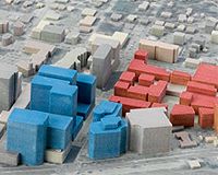
Bluesky city models are created from the most up-to-date vertical aerial photography using the latest 3D software and provide a real world, interactive, geographically accurate representation of the built environment from the desktop.

"We live in a 3D world, it is therefore essential that in order to effectively manage our urban surroundings we have a true representation of every aspect of this extremely complex environment," said Rachel Tidmarsh, Managing Director of Bluesky International.

"By creating a standard off the shelf product, to a very high specification, available in popular CAD and GIS formats we hope to revolutionise the way we manage and interact with our city centres."

Bluesky 3D City Models will be available for every city in the UK with a population over 100,000 including London, Edinburgh, Cardiff and Belfast as well as Brighton, Nottingham, Newcastle, Glasgow, Bristol and Cambridge. Created from the most up to date, high-resolution, stereo aerial photography Bluesky 3D city models map every building over 140 cubic metres.

The models also include road detail and an underlying Digital Terrain Map (DTM) to place the urban representation in its true world context.

The standard Bluesky 3D city model can be enhanced with the addition of vertical, oblique or ground photography to deliver additional detail and real world visual impact.

"The applications for these models are virtually limitless," continued Tidmarsh "Our customers are already using this type of data to communicate development plans, model and predict flood events and design and manage the delivery of urban regeneration projects."

Bluesky is a UK-based specialist in aerial imaging and remote sensing data collection and processing. An internationally recognised leader with projects extending around the globe, Bluesky has unrivalled expertise in the creation of seamless, digital aerial photography, 3D landscape/cityscape visualisations, and 3D prints.

Bluesky also runs a national mapping centre, providing digital maps, site plans, satellite imagery, aerial photography and ultra-high resolution imagery of cities and towns.

Community
Email This Article
Comment On This Article

Share This Article With Planet Earth
del.icio.usdel.icio.us DiggDigg RedditReddit
YahooMyWebYahooMyWeb GoogleGoogle FacebookFacebook


Related Links
Bluesky International
Earth Observation News - Suppiliers, Technology and Application


USGS Awards Satellite Imagery Contracts: Enhancing Access To Users
Reston VA (SPX) May 09, 2008
The United States Geological Survey (USGS) announced the award of three multi-year acquisition contracts for high and moderate-resolution satellite imagery to GeoEye of Dulles, VA, DigitalGlobe of Longmont, CO and SPOT Image Corporation of Chantilly, VA.


Memory Foam Mattress Review

Newsletters :: SpaceDaily Express :: SpaceWar Express :: TerraDaily Express :: Energy Daily
XML Feeds :: Space News :: Earth News :: War News :: Solar Energy News
  • Google wins from end of Microsoft-Yahoo affair: analysts
  • Microsoft takeover deadline for Yahoo expires without comment
  • China world's largest Internet market
  • World's Fastest Satellite Internet Connection To User Terminal Via KIZUNA

  • Arianespace Takes Delivery Of Its Third Ariane 5 In 2008
  • Orbital Awarded Contract for Suborbital Launch Vehicle Research by US DoD
  • Skynet 5C And Turksat 3A Are Fueled For The Upcoming Ariane 5 Heavy-Lift Launch
  • ISRO Scientists Meet With Prime Minister

  • China unveils new jumbo jet company: report
  • NASA And JAXA To Conduct Joint Research On Sonic Boom Modeling
  • Analysis: Can airplanes go green?
  • Belgian airline says it will cut costs, emissions by slowing down

  • Elbit Receives Order For Advanced Communications Solutions
  • Northrop Grumman To Support Roll-Out Of NATO MCCIS
  • Northrop Grumman Awarded DARPA Contract To Design Hybrid Optical/RF Communications Network
  • Joint Contracting Command Iraq Selects Proactive Communications For Task Force Iron Project

  • NASA's WMAP Poses For ESA's Gaia
  • SES ASTRA Starts New Orbital Position At 31.5 Degrees East
  • NASA Ames Partners With m2mi For Small Satellite Development
  • Loral Spins A Giant Web In Space As First ICO Bird Comes Alive

  • Bill Flynn Joins Americom Government Services to Lead Navy Programs
  • NASA names science directorate deputy
  • Northrop Grumman Names Terri Zinkiewicz VP Sector Controller For Its Space Technology Sector
  • Northrop Grumman Appoints Scott Winship To VP And Program Manager - Navy Unmanned Combat Air System

  • USGS Awards Satellite Imagery Contracts: Enhancing Access To Users
  • Bluesky Launches 3D Computer Models Of Britain's Cities
  • Cartosat 2a Puts The World In High Resolution For Indian Government
  • NASA Nasa Satellite Captures Image Of Cyclone Nargis Flooding In Myanmar

  • Rodale Garners Two National Magazine Awards
  • GIOVE-B Transmitting Its First Signals
  • Garmin, TomTom and Magellan Dominate Latest Consumer Reports GPS Navigator Ratings
  • RFMD Announces Strategic Restructuring

  • The content herein, unless otherwise known to be public domain, are Copyright 1995-2007 - SpaceDaily.AFP and UPI Wire Stories are copyright Agence France-Presse and United Press International. ESA Portal Reports are copyright European Space Agency. All NASA sourced material is public domain. Additional copyrights may apply in whole or part to other bona fide parties. Advertising does not imply endorsement,agreement or approval of any opinions, statements or information provided by SpaceDaily on any Web page published or hosted by SpaceDaily. Privacy Statement